The following details is from this webpage (pdf).
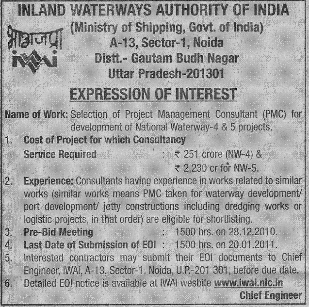
INLAND WATERWAYS AUTHORITY OF INDIA
National Waterway-4 & 5 Projects – Expression of Interest for short listing of firms for selection of Project Management Consultant (PMC) to take up development works in Public-Private-Participation (PPP) mode
Inland Waterways Authority of India (IWAI) invites Expression of Interest (EOI) from experienced consultants having proven caliber, capacity and experience in the realm of Projects related to dredging, jetty/ terminal with allied infrastructure facilities, modification of bridges & navigational locks/ aqueducts and other cross drainage works, aids to navigation and other infrastructure, their operation and maintenance etc for selected stretches of National Waterways -4 & 5 (NW-4 & 5) Projects under PPP mode.
2. Projects: Government of India has declared Kakinada-Puducherry stretch of canals along with River Godavari and Krishna as NW-4 and East Coast Canal along with River Brahmani and Mahanadi detla rivers as NW-5 w.e.f 25th November, 2008. The responsibility of development, regulation and management of these waterways now rests with IWAI.
2.1 The stretch-wise break up of the NW-4 is given below:-
River Godavari (Bhadrachalam to Rajahmundry)- 157 km
River Krishna (Wazirabad to Vijayawada) – 171 km
Kakinada Canal ( Kakinada to Rajahmundry) – 50 km
Eluru Canal (Rajahmundry to Vijayawada) – 139 km
Commamur Canal ( Vijayawada to Pedaganjam) – 113 km
North Buckingham Canal (Pedaganjm to Chennai) – 315 km
South Buckingham Canal (Chennai to Merkanam) – 110 km
Kaluvelly Tank (Markanam to Puducherry) – 22 km
Total – 1077 km
Of this, 888 km length of waterway falls in Andhra Pradesh, 187 km in Tamil Nadu and 2 km in Union Territory of Puducherry.
In 50 km stretch of Buckingham Canal in Chennai area (Ennore to Muthukadu) there is no proposal for development of waterway due to the stretch being heavily encroached by MRTS and being urban area. Thus the effective length of waterway development is only 1027 km.
2.2 The stretch-wise break up of NW-5 is given below:
Rivers Brahmani-Kharsua- Dhamra (Talcher- Dhamra) – 265 km
Matai river (Charbatia- Dhamra) – 39 km
Mahanadi delta rivers (Mangalgadi- Paradeep) – 67 km
East Coast Canal (Geonkhali- Charbatia) – 217 km
Total – 588km
Of this 91 km of waterway is in West Bengal and the rest is in Orissa.
2.3. Considering limitation in availability of funds during 11th Plan it has been decided to explore the possibility of development of more viable stretch of the waterways under PPP mode with Viability Gap Funding (VGF) by the Govt of India, if so required. Further, based on the interaction with possible stake holders in development of these waterways it has been decided by the Ministry of Shipping, Govt of India to explore the possibility to develop the following stretches of waterways under Public-Private- Partnership (PPP) route, at the first instance.
Project-1 (NW-4- Godavari river, Kakinda canal and Godavari Eluru canal)
River Godavari (Bhadrachalam- Rajahmundry) – 157 km
Kakinada Canal (Kakinada-Rajahmundry) – 50 km
Godavari Eluru Canal (Rajahmundry- Eluru) – 88 km
Total – 295 km
Project- 2 (NW-5- Brhamani-Kharsua-Dhamra- Matai river system and Mahanadi delta rivers)
River Brahmani- Kharsua- Dhamra river (Talcher- Dhamra)- 265km
Matai river (Charbatia- Dhamra) – 39 km
Mahanadi delta rivers (Mangalgadi- Paradeep) – 67 km
Total – 371km
3. Project Components: The various components of these Projects are:
Project-1
a) Development of the navigable channel (of the following dimension) along with land acquisition for widening the narrow canals and provision of aids to navigation:
i) River Godavari
Bottom width – 32m
Depth – 1.8 m
Side slope – 1:5
This waterway stretch will facilitate movement of 350 tonnes vessel of 45 m length x 9 m breadth x 1.5 m loaded draft.
ii) Kakinada Canal & Godavari Eluru Canal
Bottom width – 14m
Depth – 1.6 m
Side slope – 1:3
This waterway stretch will facilitate movement of 100 tonnes vessel of 32 m length x 5 m breadth x 1.2 m loaded draft.
b) Construction of Inland Water Transport(IWT) Terminals and related infrastructure facilities (including land acquisition) at 3 locations namely Kakinada, Rajahmundry and Eluru
Project-2
a) Development of the navigable channel (of the following dimension) along with land acquisition for widening the narrow stretches and provision of aids to navigation: Brahmani-Kharsua-Dhamra river system, Matai river and Mahanadi delta rivers
Bottom width – 45 m
Depth – 2m
Side slope – 1:5
This waterway stretch will facilitate movement of 500 tonnes vessel of 50 m length x 11 m breadth x 1.8 m loaded draft. b) Construction of Inland Water Transport(IWT) Terminals and related infrastructure facilities (including land acquisition) at 4 locations namely Talcher, Jenapur, Dhamra & Paradeep (port facilities).
4. Quantum of works & Cost: DPRs have been prepared by the consultant namely M/s WAPCOS (I) Ltd, New Delhi for both the waterways. The quantum of works estimated in the DPR is as under:
Project-1:
a) Estimated Quantity:
Item – Quantity
i) Land Acquisition- 517 Ha
ii) Dredging- 19.12 lakh cu.m
iii) Bank Protection- 0.50 lakh cum
iv) Modification of structures- 496 pipe sluices+ 7 locks + 2 bridges
v) Navigational Aids- 125 FRP Buoys + 125 countryboats + 22 shore beacons + 273 lighted marks
vi) Buoy Laying Vessel- One
b) Estimated Cost: (in Crores)
i) Land acquisition- 118
ii) Dredging- 39
iii) Removal of pipe sluices- 6
iv) Modification of Locks- 8
v) Modification of Bridges- 12
vi) Navigational aids- 10
vii) Protection measures- 3
viii) Terminals – 48
ix) Facilities to local people for ferry Service etc.- 7
Total – 251
Project 2
a) Estimated Works:
Item – Quantity
i) Land acquisition- 23 Ha
ii) Dredging- 10 Million cu.m
iii) Barrages – 5
iv) Bank Protection- 0.76 Million cum
v) Navigational Locks- 5 (with barrages) + 2
vi) Navigational Aids- 190 Buoys + 55 beacons
vii) Buoy Laying vessel – One
b) Estimated Cost (in cr.)
i) Land acquisition- 2
ii) Dredging- 185
iii) Barrages with locks – 1598
iv) Raising banks- 245
v) Protection measures- 39
vi) Fenders – 1
vii) Terminals – 72
viii) Navigational Aids- 11
ix) Navigational Locks- 45
x) Bridges- 14
xi) For EMP implementation- 6
xii) For local public amenities- 12
Total – 2230 at 2010 prices.
The duration of completion of the project shall be Five Years, each. Thereafter, the selected concessionaire/ contractor has to maintain the project for a further period of 10 years.
Executive summary of the DPRs can be downloaded from our website www.iwai.nic.in. Other volumes of the DPRs can also be obtained from IWAI by the prospective bidders on payment basis.
5. Scope of assignment for the consultant: The selected consultant has to act as the representative of IWAI in monitoring the execution of project under PPP route. The consultant inter-alia has to prepare the PPP documents for selection of concessionaire/ contractors, check the adequacy of design of each component of works, do bid process management on behalf of IWAI, monitor and ensure quality of the work done by the contractors till the waterways stretches of Project -1 & 2 become fully functional/ operational. The waterways have to be developed for for providing 24 hour navigation for at least 330 days in a year with necessary infrastructure facilities
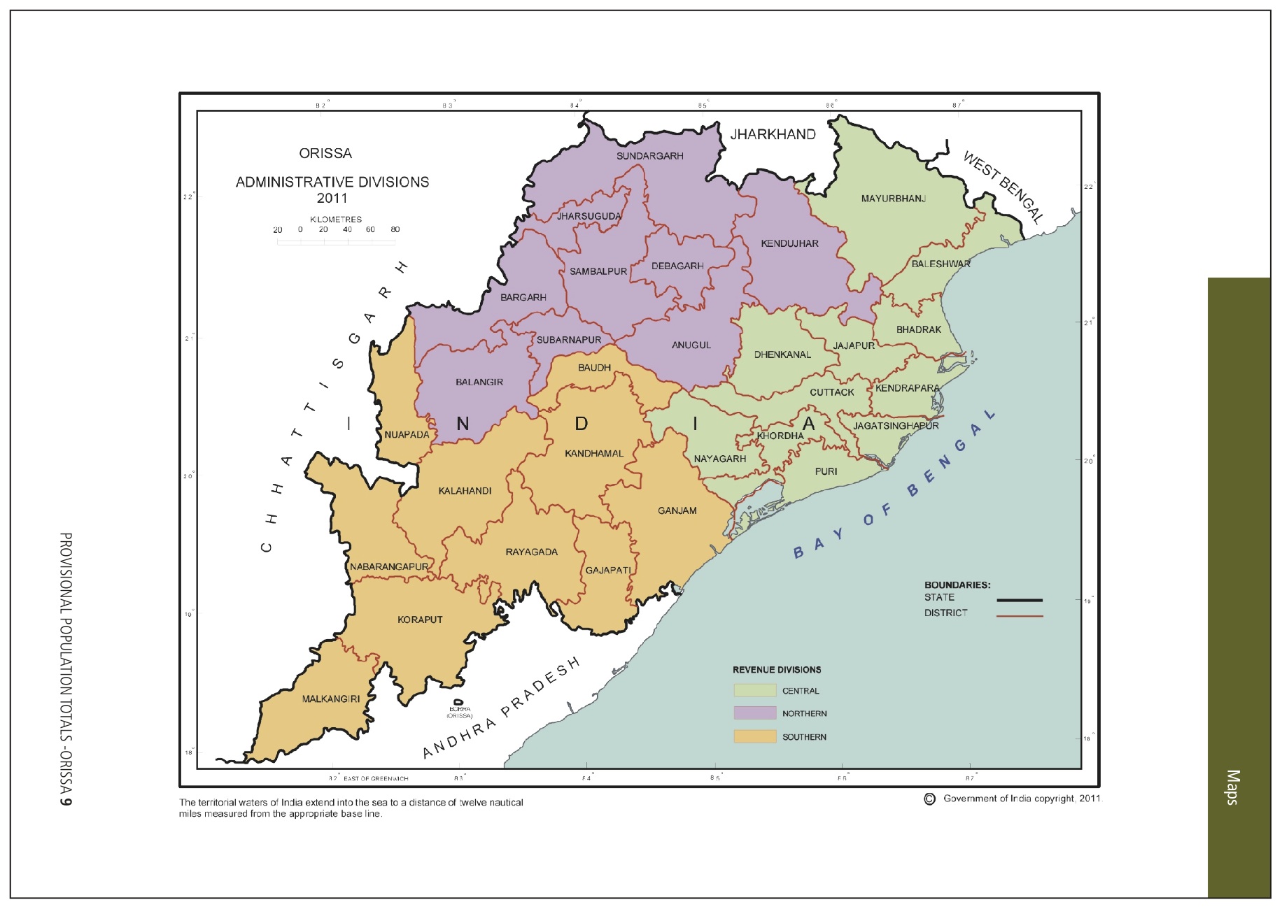
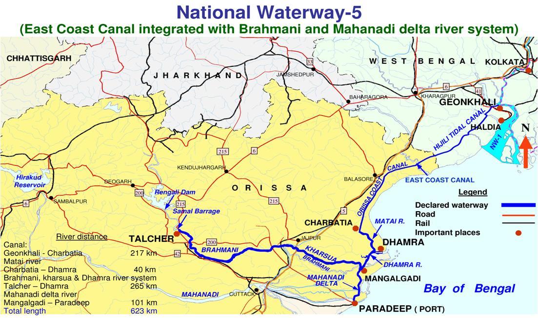 My thoughts: The National Waterway 5 would be a huge benefit to Odisha. Basically it will run from Talcher – Kalinganagar area (Jenapur) – to Mangalgadi (a point in between Paradeep and Dhamara) and would connect Paradip to Dhamara to a point near Kolkata. The National waterway 1 runs from Kolkata to Alalhabad (Prayag) via Patna and Varanasi. I am not fully sure if the connection between NW 5 and NW 1 is seamless. Some maps suggest that while others suggest the opposite. But regardless, if Odisha takes proper advantage of this, this would be huge. Following are some possibilities.
- Rail and highways could be planned along the bank of the waterway. While the central govt. is acquiring land for the waterway, the state should acquire land for rail and highways along the bank. This will form a big part of the coastal highway and railway that Odisha has been thinking about for a long time.
- The waterway would have tremendous tourism potential, both short tours as well long ones which can take people all the way to Prayag (Allahabad) and Varanasi and people can even take the sea route from Paradeep and go up to Puri (once some ports near Puri are developed.)
- Appropriate industries can be targeted all along the waterway. Districts such as Kendrapada, which do not have any industries and want to have them, can take advantage of the connectivity provided by this, and entice appropriate industries.
- This waterway will be a very long stretch close to the coast, all the way from Paradeep to near Kolkata.The area along the water way in both sides, as well as the area between the waterway and the Bay of Bengal and the beautiful beaches and the tourism spots (like Bhitarakanika) could be made to a special tourism zone with all kinds of tourism related projects.
April 21st, 2011 | Chitta Baral | Comments Off on Update on the progress with respect to the National Waterway 4 and 5


 My thoughts: The National Waterway 5 would be a huge benefit to Odisha. Basically it will run from Talcher – Kalinganagar area (Jenapur) – to Mangalgadi (a point in between Paradeep and Dhamara) and would connect Paradip to Dhamara to a point near Kolkata. The National waterway 1 runs from Kolkata to Alalhabad (Prayag) via Patna and Varanasi. I am not fully sure if the connection between NW 5 and NW 1 is seamless. Some maps suggest that while others suggest the opposite. But regardless, if Odisha takes proper advantage of this, this would be huge. Following are some possibilities.
.gif)
