Archive for the 'Kalinganagar – Panikoili – Jajpur – Kendrapara' Category

Odisha initiates plans for a Capital Area Development Region

Bhubaneswar, Bhubaneswar- Cuttack- Puri, Bhubaneswar-Berhampur, Bhubaneswar-Cuttack- Kalinganagar, Bhubaneswar-Dhenkanal- Anugul, Bhubaneswar-Nayagarh, Bhubaneswar-Paradip, Bhubaneswar-Pipli- Astaranga, Bhubaneswar-Pipli- Konark, Bhubaneswar-Puri, Choudwar-Kendrapara - Dhamara, Cuttack, Cuttack, Cuttack-Paradip, Dhenkanal, Jagatsinghpur, Jajpur, Jajpur Rd- Vyasanagar- Duburi- Kalinganagar, Kalinganagar - Panikoili - Jajpur - Kendrapara, Kalinganagar- Chandikhol- Paradip, Kendrapada, Khordha, Odisha govt. action, Paradip - Jatadhari - Kujanga, Puri, Puri, Puri - Konark, URBAN DEV. & RENEWAL 1 Comment »
The above is a good idea.


  • A plan over a larger area will avoid congestion and slums that are typical of densly packed areas.
  • Another big benefit will be that the term "Capital Area" will make it easier for institutions, companies and other entities to come to the gretaer area rather than coming to "Bhubaneswar". For example, many institutions that are looking for land in Bhubaneswar are hesitant to locate in Kendrapada or Jagatsinghpur; even though the political leadership is very welcoming.  But once the term "Capital Area" encompasses Kendrapada and Jagatsinghpur, these institutions will be less hesitant to come there.

So while the current Bhubaneswar and Cuttack planned areas will sever as the core urban area, the larger Capital Area development region will morph to a sub-urban area which down the road will touch the metropolitan areas around Angul in the west and Berhampur in the south.

We wrote about this in http://www.orissalinks.com/orissagrowth/archives/3637.

A similar term needs to be coined for the greater Sambalpur-Jharsuguda-Rourkela area. See http://www.orissalinks.com/orissagrowth/archives/3660 , http://www.orissalinks.com/orissagrowth/archives/3672 and http://www.orissalinks.com/orissagrowth/archives/3668.

Perhaps it can be called the "Western Odisha Development Region".

Railways around Greater Kalinganagar

Angul, Angul - Talcher - Sukinda (under constr.), Bhadrakh, Bhadrakh-Sarla Rd...Vizag, Cuttack, Cuttack - Paradeep, Dhenkanal, ECOR, Haridaspur - Paradeep (under constr.), Jagatsinghpur, Jajpur, Jajpur Rd- Vyasanagar- Duburi- Kalinganagar, Jakhapura - Daitari, Kalinganagar - Kamkhya Nagar - Talcher, Kalinganagar - Panikoili - Jajpur - Kendrapara, Kalinganagar - Tarini - Keonjhar, Kalinganagar corridors, Kalinganagar- Chandikhol- Paradip, Kendrapada, Keonjhar, Khordha, Railway maps, Railways, Rajathagara - Nergundi, Talcher - Barang Comments Off on Railways around Greater Kalinganagar

ecor-status-april1-2007-greater-knagar.JPG

One step closer for the national waterway in Orissa

Angul, Balasore, Bhadrakh, CENTER & ODISHA, CORRIDORS, Cuttack, Dhenkanal, INVESTMENTS and INVESTMENT PLANS, Jagatsinghpur, Jajpur, Kalinganagar - Kamkhya Nagar - Talcher, Kalinganagar - Panikoili - Jajpur - Kendrapara, Kalinganagar corridors, Kalinganagar- Chandikhol- Paradip, Kendrapada, National Waterway 5, Ports and waterways Comments Off on One step closer for the national waterway in Orissa

Some of the earlier news reports on national waterways in Orissa are linked from this site. Following is the latest development, as reported in an Indian Express article. Excerpts:

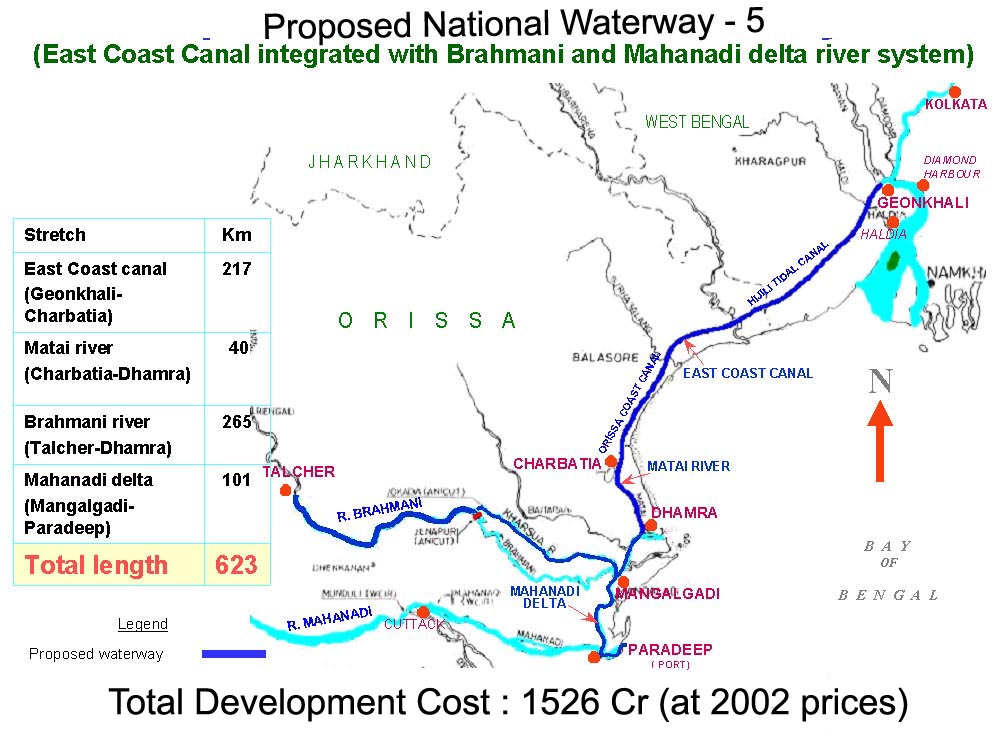
The Parliamentary Standing Committee has shown the green signal to two new national waterways in West Bengal-Orissa and Andhra Pradesh-Tamil Nadu even as it called for an integrated transport policy and an institutional framework for inland water transport. … The other waterway—Talcher-Dhamra stretch of the Brahmni-Kharsua-Dhamra Rivers, Goenkhali-Charbatia stretch of the East Coast canal, Charbatia-Dhamra stretch of Matai River and Mahandai delta rivers between Mangalgadi and Paradip is also up for the national waterway status. Around 18.07 million tonnes of inland water transport traffic is expected to be carried out on the proposed waterway after its full development in eight years time. The traffic is expected to be handled at four terminals—Talcher, Nasirabd, Balasore and Rajnagar and the major cargoes are coal, fertiliser, cement, iron ore, agricultural and industrial products. The Standing Committee, however, has recommended the Government to prepare the road map for an integrated transport policy to include inland water transport, coastal shipping, civil aviation, road transport & highways for enabling better inter-connectivity amongst multiple modes of transport. The Committee has also called for provision of an institutional framework for development of IWT sector so as to increase capacity of IWT agencies, increased cost recovery and commercialisation of IWT industries. In case of the West Bengal-Orissa waterway, the Committee has suggested that another terminal be developed at Geonkhali in West Bengal to enable better traffic handling. It was also noted by the panel that there’s need to develop an action plan to address the growing demand of repair and service facilities of IWT vessels.

The final step for the bill would be to getting approval in both houses of the parliament. nw5.jpg

Following up on the standing committee’s recommendation it may be appropriate to establish an airport near Jenapur-Kabatabandha as the ECOR Howrah-Chennai Railway line and NH 200 (Chandikhol-Sukinda-Talcher) intersects the national waterway at that point; NH 5A (Chandikhol-Paradip), NH 5 (Panikoili-Chandikhol) and NH 215 (Panikoili-Keonjhar) are close by; Haridaspur – Paradeep railway line will start very near to that point; Jakhapura-Banspani line also starts close to that point and that airport will serve the greater Kalinga Nagar area where multiple steel plants and other plants are coming up. Going further on that, the Orissa government is supposed to have made a master plan for Kalinga nagar. Following is an excerpt from a year old report (May 28, 2006) in Steelguru on that. (See also this New Indian Express report)

Orissa government has decided to prepare a master plan for Kalinga Nagar in Jajpur district. South Africa based Lea Associates will prepare the master plan in collaboration with School of Planning and Architect, New Delhi and the Centre for Environment and Planning. The master plan will be completed by July. Kalinga Nagar Industrial Area will be developed for a population of over 10 lakh keeping an eye on 2025 and will be extended to 177 square kilometers. As per the draft, the KNIA will be extended to 134 villages. So far 112 villages have been included in the industrial area. About 1 million hectare land will be acquired by the Government in a phased manner for the development of the area. According to the draft plan, 68 square kilometer out of the total area will be reserved for town planning. About 89 square kilometer will be earmarked for industrial units while 20 square kilometer will be reserved for development of different infrastructure including bus stand, hotels, schools and hospital. Decision has also been taken to set up Kalinga Nagar Development Authority.

Roads and Highways infrastructure in Orissa

Angul, Balangir, Balasore, Bargarh, Baripada-Balasore-Kirtania, Bhadrakh, Bhadrakh-Balasore, Bhadrakh-Dhamara, Bhubaneswar-Berhampur, Bhubaneswar-Cuttack- Kalinganagar, Bhubaneswar-Dhenkanal- Anugul, Bhubaneswar-Nayagarh, Bhubaneswar-Paradip, Bhubaneswar-Pipli- Astaranga, Bhubaneswar-Pipli- Konark, Bhubaneswar-Puri, Bouda, Choudwar-Kendrapara - Dhamara, Coastal highway, Corridors emanating from Bhubaneswar metro, Cuttack, Cuttack-Paradip, Deogarh, Dhenkanal, DISTRICTS & BLOCKS, Gajapati, Ganjam, Grama sadak, Jagatsinghpur, Jajpur, Jharsuguda-Sambalpur- Bargarh, Jharsugurha, Kalahandi, Kalinganagar - Kamkhya Nagar - Talcher, Kalinganagar - Panikoili - Jajpur - Kendrapara, Kalinganagar - Tarini - Keonjhar, Kalinganagar- Chandikhol- Paradip, Kalinganagar-Bhadrakh, Kandhamala, Kendrapada, Keonjhar, Khordha, Koraput, Malkangiri, Mayurbhanj, Mining Corridor, Nabarangpur, National Highways, Nayagarha, NH 200 (440 Kms: Chhattisgarh - Jharsuguda - Deogarh - Talcher - Kamakhyanagar - Duburi - Chandhikhol), NH 201 (310 Kms: Boriguma - Bhawanipatna - Balangir - Bargarh), NH 203 (97 Kms: Bhubaneshwar-Pipili-Puri-Konark), NH 203A (49 Kms: Puri - Bramhagiri - Satpada), NH 215 (348 Kms: NH-5@Panikoli - Anandapur - Kendujhargarh -Rajamundra @NH-23), NH 217 (438 Kms: Chhattisgarh Border - Khariar Rd - Nuapada - Khariar - Titlagarh - Ramapur - Baligurha - Asika - Brahmapur - Gopalpur), NH 224 (298 Kms: Khordha - Nayagarh - Dashapalla - Bauda - Sonapur - Balangir), NH 23 (209 Kms: Jharkhand Border - Rourkela - Rajamundra - Pala Laharha - Talcher - NH-42), NH 42 (261 Kms: NH-6@Sambalpur - Redhakhol - Anugul - Dhenkanal - NH-5@Nergundi), NH 43 (152 Kms: Chhattisgarh Border - Chandili - Borigma - Jaypur - Koraput - Sunki - Andhra Pradesh Border), NH 5 (488 kms: NH No.6 in Jharkhand - Baripada - Baleshwar - Bhadrakh - Cuttack - Bhubaneswar - Khordha - Brahmapur - upto Andhra Pradesh Border), NH 5A (77 Kms: NH-5 at Chandikhol to Paradip), NH 6 (462 Kms: Chhattisgarh Border - Lobarchatti - Bargarh - Sambalpur - Deogarh - Kendujhargarh - Jashipur - Bangriposi - Jharkhand Border ), NH 60 (57 Kms: West Bengal Border- Jaleswar - Baleshwar), NH 75 (18 Kms: Jharkhand Border to NH-215 near Parsora), Nuapada, Overall Odisha, Puri, Puri - Konark, Rayagada, Road maps, Roads, highways and Bus stands, Rourkela-Jharsuguda, Sambalpur, Sonepur, State highways, Sundergarh, Vijaywada-Ranchi highway Comments Off on Roads and Highways infrastructure in Orissa


In recent years there has been a big jump in the number of kilometers of national highways in Orissa. Following is copied from my page "Roads and Highways infrastructure in Orissa."

Road network: Orissa Roads1; Orissa Roads2; India’s NH network; India’s golden quadrilateral; the part of the GQ/NH-5 that runs through Orissa.

  • National Highways in Orissa and India; its growth in recent years:
    • NH 5: Junction with NH No.6 in Jharkhand near Baharagora-BaripadaBaleshwar-Bhadrakh-Cuttack- Bhubaneswar-Khordha-Chhatrapur-Brahmapur– upto Andhra Pradesh Border. (488 kms)
    • NH 5A: Junction with NH No.5 near Haridaspur-Paradip Port. (77 kms)
    • NH 6: From Chhattisgarh Border-Lobarchatti- BargarhSambalpur-Deogarh-Barakot- Kendujhargarh -Jashipur-Bangriposi-upto Jharkhand Border (462 kms)
    • NH 23: From Jharkhand Border-Panposh-Raurkela– Rajamundra-Barakot- Pala Laharha-Talcher-Jn. with NH-42 (209 kms)
    • NH 42: Junction with NH No.6 near Sambalpur– Redhakhol-Anugul-Dhenkanal- Jn. with NH-5 near Cuttack. (261 kms)
    • NH 43: From Chhattisgarh Border– Dhanpunji- Borigma- JaypurKoraput-Sunki- Andhra Pradesh Border. (152 kms)
    • NH 60: From West Bengal BorderJaleswarBaleshwar (57 kms)
    • NH 75: From Jharkhand Border to junction with NH No.215 near Parsora (18 kms)
    • NH 200: From Chhattisgarh-Machida-Jharsuguda– Kochinda- Deogarh –Talcher-Kamakhyanagar-Sukinda- Chandhikhol (440 kms)
    • NH 201: Boriguma-Ampani-Bhawanipatna– Belgan- Balangir-Luisinga-Jogisuruda-Dunguripali-Bargarh (310 kms)
    • NH 203: Bhubaneshwar-Pipili-PuriKonark (97 kms)
    • NH 203A: The highway starting from its junction with NH-203 at Puri, connecting Bramhagiri and terminating at Satpada (49 kms)
    • NH 215: Panikoli-Anandapur-Ghatgan- Kendujhargarh– Parsora-Koira-Rajamundra (348 kms)
    • NH 217: From Chhattisgarh Border-Nauparha-Khariar- Titlagarh-Belgan- Ramapur- Baligurha-Sorada-Asika- Brahmapur– Narendrapur- Gopalpur (438 kms)
    • NH 224: Khordha-Nayagarh-Dashapalla- Purunakatak-Bauda-Sonapur-Balangir (298 kms)
  • Vijaywada-Ranchi highway (approved by planning commission as reported in May 2006), [July 06] [The Orissa government has been demanding a NH from Vijaywada to Ranchi which will pass through the Naxal infested areas. 1200 km of this 2000km will be in Orissa. CM talked to planning comission about it.]
  • Ongoing National Highway work in Orissa
  • Future plans for Orissa: [1:april-28-05]; [2:april-28-05].
  • Various phases of NHDP: [1]; [2]; [3]
  • Other highway plans:
    • 4 laning of Chandikhol-Paradip by February-end of 2007
    • 4 laning of Keonjhar-Panikoili, Duburi-Talcher, Cuttack-Paradeep and Duburi-Keonjhar Highways. [June17-05-Pragativadi]
  • Aim-for-with-high-priority/parts-of-it-in-Orissa-govt- plan(page4)-already:
    • Connect NH 215 (perhaps at Jajpur Rd) to Jenapur to NH200 (where it meets Brahmani) with a highway as Jenapur is the location where the National waterway will cross the railway line and Jenapur is 7 kms from where a branch of the line goes to Daitari and Bansapani.
    • Designate AP-border-Koraput-Raygada-Padampur- Berhampur (in NH5) as a National highway. (This will bring Koraput and Raygada, thus a big part of KBK, closer to BBSR) — a slight revision of what is in the plan
    • Designate Anandpur (NH 215)-Bhadrak-Dhamara port as an NH. (This will bring Dhamara port closer to Jharkhand, thus helping industries in Jharkhand and Orissa.)
    • Jagatpur-Kendrapara-Chandbali-Dhamara — make it an NH (alternative route to Dhamara port)
    • Panikoili/Kuakhia-Jajpur-Aradi-Chandabali — make it an NH (alternative route to Dhamara port)
    • Panikoili-Jajpur-Kendrapara-NH5a-Paradeep — make it an NH (alternative to Paradeep port)
  • Orissa State Road Transport Company (OSRTC)
  • Wide city roads:
    • Four-laning of the Airport-Dhamana Chhaka road in Bhubaneswar: [1]
    • Other Bhubaneswar Road plans: [1], [2]
  • Bhubaneswar area road plans: