Archive for the 'Bhubaneswar and vicinity' Category

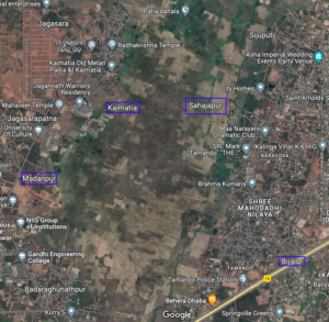
A masterplan for a site near Infovalley

Bhubaneswar and vicinity, Bhubaneswar- Cuttack- Puri, Khordha, Satellite and Residential townships Comments Off on A masterplan for a site near Infovalley

Google Map Link: https://www.google.com/maps/@20.2471662,85.7396776,3429m/data=!3m1!1e3

In Design Studio Ahmedabad has developed a master plan for the above area. See details at https://www.inidesignstudio.info/dev/portfolio/town-planning-scheme-tps-02-bhubaneswar/

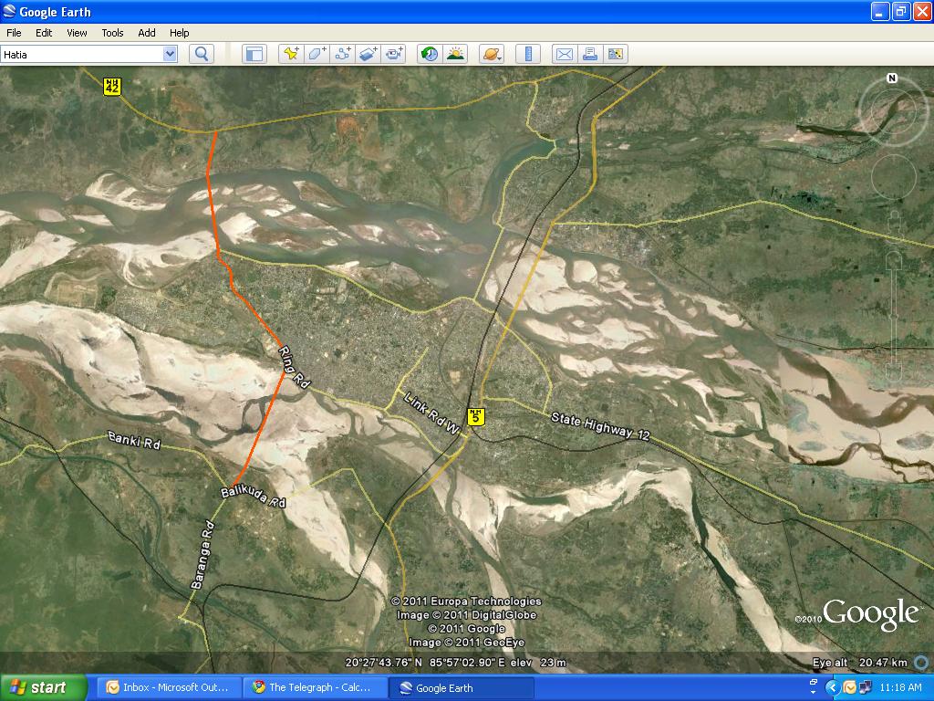
Bridge on Kathjodi near Trisulia would decrease the distance between Bhubaneswar and Cuttack by 10 km

Bhubaneswar and vicinity, Bhubaneswar- Cuttack- Puri, Bhubaneswar-Cuttack- Kalinganagar, Cuttack Comments Off on Bridge on Kathjodi near Trisulia would decrease the distance between Bhubaneswar and Cuttack by 10 km

Following are excerpts from a report in Telegraph.

The proposed bridge from CDA Square up to Trisulia and Baranga, which is said to be longest and first of its kind three-lane bridge in the state, would act as ‘direct-link’ between Cuttack and Bhubaneswar.

… “The distance between Cuttack and Bhubaneswar would be reduced by 10km after the completion of the project. Efforts are on by the government for the all-round development of Cuttack and I hope the new project would be completed on time,” Naveen said.

… With the construction of the second bridge, one would have to cover a distance of only 20km from CDA square to Jaydev Vihar via Nandankanan and Trisulia. The length of the bridge would be 2.8km and it would also have footpaths for pedestrians and cycles on both sides and dividers and railing. The cost of the total project was estimated to be around Rs 122crore.

… The project, to be built in assistance of National Bank of Agriculture and Rural Development (NABARD), is expected to be completed within three years.

The three-lane bridge would not only solve precious time of the people, it will also create new vistas for development in Barang and nearby areas which are also in an expansion mode. The project has been targeted to be completed within three years from the date of agreement with the company, Pradhan said.

… Apart from this, there is also a proposal to construct another bridge over Mahanadi river. The bridge would connect Pitapali area near Khurda with Dhenkanal on NH-5 via Manguli square. The existing route distance would be reduced to 71.5 km from 93km. The project is also likely to take off soon.

The last paragraph is confusing. Pitapali, Dhenkanal and Manguli Square form a triangle. It could mean the proposed bridge near Jatamundia in the following map.

Or, as suggested by reader Debi Prasanna Sarangi, it could mean the bridge over Mahanadi in the following map. (Note: The point where NH-5 meets NH-42 is called Manguli Square.)

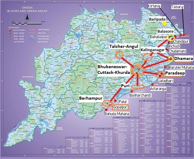
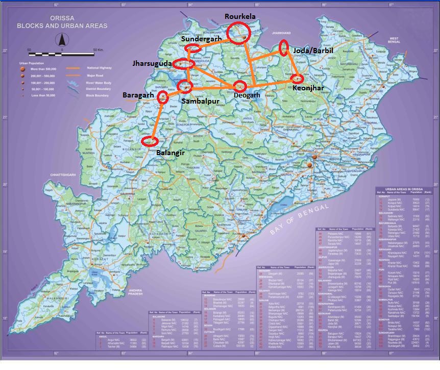
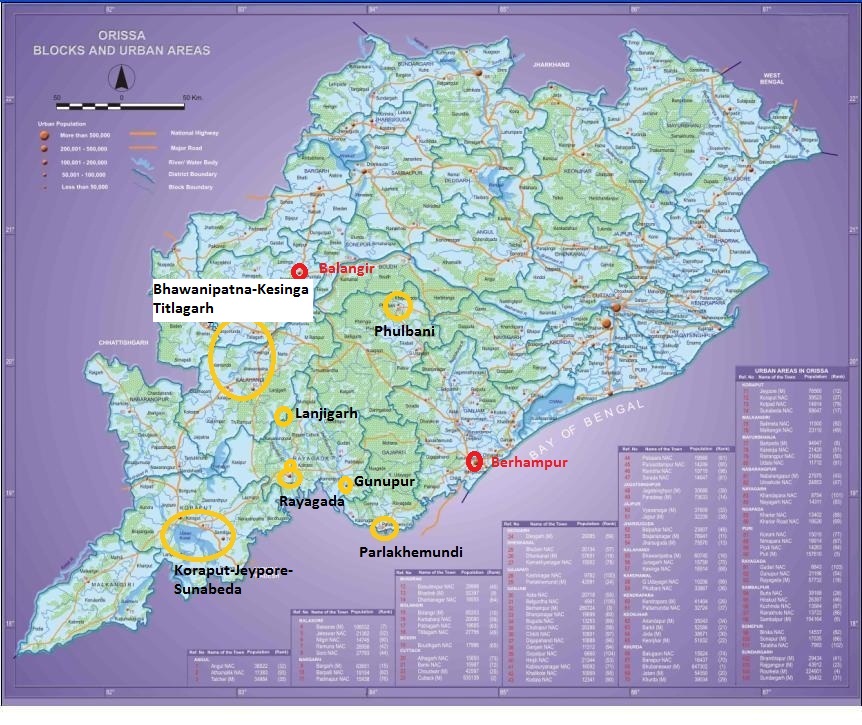
Development locations in the three regions of Odisha – in maps

Anugul- Talcher - Saranga- Nalconagar, Balasore- Chandipur, Baripada- Bangiriposi- Similipal foothills, Berhampur- Gopalpur- Chhatrapur, Bhubaneswar and vicinity, Bhubaneswar- Cuttack- Puri, Dhamara- Chandbali- Bhitarakanika, Jajpur Rd- Vyasanagar- Duburi- Kalinganagar, Jharsugurha- Brajarajnagar- Belpahar, Koraput- Jeypore- Sunabedha- Damanjodi, Overall Odisha, Paradip - Jatadhari - Kujanga, Rayagada- Therubali, Rourkela- Kansbahal, Sambaplur- Burla- Bargarh- Chipilima 1 Comment »

The Coastal Belt.

The Western Industrial Belt.

The Southwestern & Central Outposts.

Envisioning the 150 km radius around Bhubaneswar in 20 years

Angul, Anugul- Talcher - Saranga- Nalconagar, Balasore, Balasore- Chandipur, Berhampur- Gopalpur- Chhatrapur, Bhadrakh, Bhubaneswar and vicinity, Bhubaneswar- Cuttack- Puri, Cuttack, Dhamara- Chandbali- Bhitarakanika, Dhenkanal, Ganjam, Jagatsinghpur, Jajpur, Jajpur Rd- Vyasanagar- Duburi- Kalinganagar, Khordha, Paradip - Jatadhari - Kujanga, Puri 5 Comments »

In 20 years (i.e., in 2030) the Bhubaneswar-Cuttack-Khurda population would be around 4 million plus. In addition the area would be surrounded by the following cities/towns within 150 kms radius (i.e., about a hour and half away).

  • Berhampur-Gopalpur to the south (with a then population of 1.5 million; about 145 kms away)
  • Puri to the south (with a then population of 700K; only 30kms away)
  • Kalinganagar to the North (with a then population of 500K; only 50 kms away)
  • Talcher-Angul to the West (with a then population of 500K; only 110 kms away)
  • Dhenkanal to the west (with a then population of 200K and almost in the periphery)
  • Paradip to the east (with a then population of 400K and 90 kms away)
  • Dhamara-Chandbali to the Northeast (with a then population of 200K and 140 kms away)
  • Bhadrak to the North (with a then population of 200K and 140 kms away)

A little farther is

  • Balasore-Chandipur to the North (with a then population of 300K and 162 kms away from the Northern end of Bhubaneswar-Cuttack-Khurda area)

In addition there will be several port towns other than the ones mentioned above and a few smaller towns (For example, Nayagarh)  within 200km radius of greater Bhubaneswar.

Besides individual CDPs for these areas the Odisha governement should start making plans for this larger overall area. It would form a different kind of megalopolis than New Delhi, Mumbai or Kolkata with a well planned hub (Bhubaneswar) surrounded by mini-hubs and with rural areas in between. I can not off-hand think of another such area in the world; may be the readers can point me to some. Please suggest what kind of plans need to be made. (Please note that for something to be up and running in 20 years, plans need to be made now.) For example:

  • Commuter trains at frequent intervals and the necessary infrastructure for that. Following are some of the segments
    • Bhubaneswar-Puri-Konark-Astaranga (Puri-Konark-Astaranga needs to be built; alternatively if Astaranga port comes up, then there may be a new line from Barang to Astaranga)
    • Bhubaneswar-Berhampur-Gopalpur (Berhampur-Gopalpur needs to be built)
    • Bhubaneswar-Jajpur Rd(Kalinganagar)-Bhadrak-Dhamara (Bhadrak-Dhamara is ready but no trains yet)
    • Bhubaneswar-Jajpur Rd(Kalinganagar)-Bhadrak-Balasore-Baripada
    • Bhubaneswar-Jakhapura(Kalinganagar)-Tomka (on the line to Kendujhargarh)
    • Bhubaneswar-Cuttack-Paradeep (ready)
    • Bhubaneswar-Dhenkanal-Talcher-Angul (ready)
    • Bhubaneswar-Khurda-Nayagarh and beyond (being constructed; part of Khurda-Balangir)
    • Angul-Talcher-Sukinda-Kalinganagar (being constructed)
  • Expressways linking these places
  • Fast buses linking these places
  • Fast airport shuttle
  • Some of these places would be connected by waterways including National Waterway 5
  • Express ring road around each of these places
  • Co-ordinated public transport in each of these places
  • ??

Please let your imagination run wild!

Cuttack people unhappy with trains bypassing Cuttack: An easy solution

Bhubaneswar and vicinity, Bhubaneswar- Cuttack- Puri, Cuttack, ECOR, Khordha, Railway maps 1 Comment »

Recently unhappiness is brewing because of various trains bypassing Cuttack. See the following news item from Samaja.
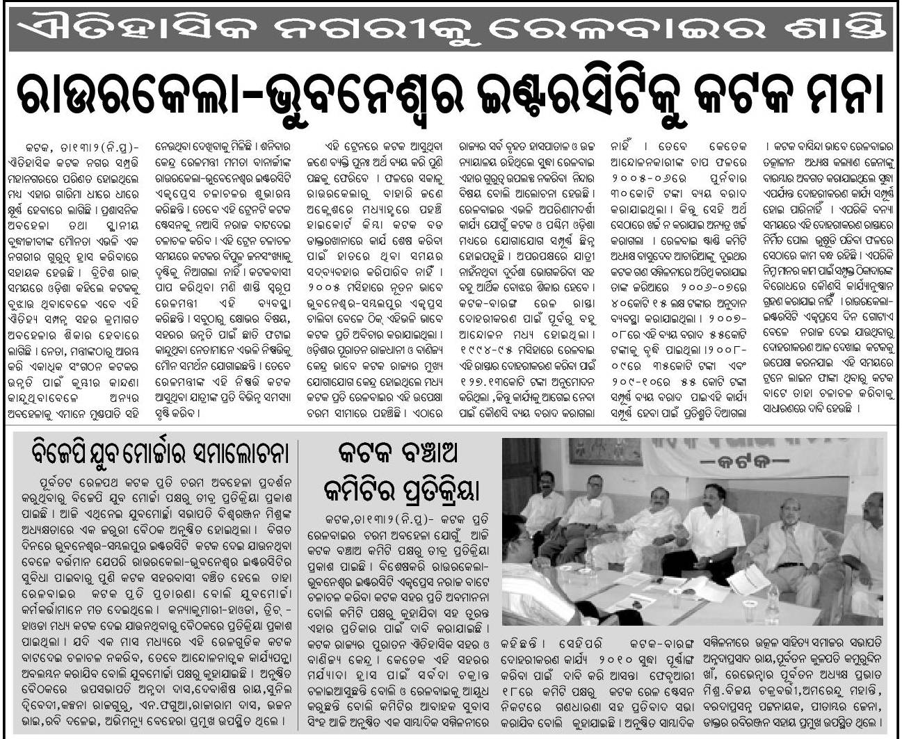
I believe there is a easy solution to this: Develop the Naraj station to have express train stops and develop the accessibility of the Naraj station from the roads that goes from Naraj to Bidanasi side of Cuttack.

I wrote about it earlier in http://www.orissalinks.com/orissagrowth/archives/1967. Following are some excerpts from that article.

Naraj Station lies across Kathjodi river about 1 km away from the bridge. It is about 2 kms from the proposed 2nd campus of Ravenshaw university, 3-4 km from Bidanasi-CDA and within 1 km from the proposed Sri Sri University. 

Several trains in the BBS (Bhubaneswar)-SBP (Sambalpur) line such as 2893 (BBS-BLGR superfast), 8304 (Puri-SBP Intercity), 8405 (Puri-ADI), 8507 (VSK-ASR) skip Cuttack and go via Naraj without stopping there. By developing the Naraj station a bit more, developing the road between the station and the bridge, and introducing stops at Naraj station people in Cuttack will be able to easily access these trains.

… Naraj is really very close to Cuttack; much close to Cuttack than Barang or the proposed station between Barang and Patia. Also, Naraj station is much closer to the newer parts of Cuttack (such as CDA and Bidanasi) than the Cuttack station. Also, a lot of development is planned near Naraj that includes the Sri Sri University, National Law University and 2nd campus of Ravenshaw University. …

There were some concerns regarding the overlap with the proposed New Barang station between Patia and Bhubaneswar. I think with the rate Cuttack-Bhubaneswar area is growing even if a major station in the form of a New Barang station comes up, it will be still a good idea to have a express stop station in Naraj.

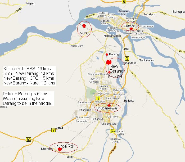
In the not too far future the greater Bhubaneswar area would need five stations: Khurda Rd, Bhubaneswar, New Barang, Cuttack and Naraj. The following map shows the five stations and the distance between them.
 

Proposed road network in the Bhubaneswar development plan area

Bhubaneswar and vicinity, Bhubaneswar- Cuttack- Puri, Khordha, NH 5 (488 kms: NH No.6 in Jharkhand - Baripada - Baleshwar - Bhadrakh - Cuttack - Bhubaneswar - Khordha - Brahmapur - upto Andhra Pradesh Border), Road maps, Roads, highways and Bus stands 2 Comments »

Population of Bhubaneswar – Cuttack urban complex is 1.9 million in 2008

Bhubaneswar and vicinity, Bhubaneswar- Cuttack- Puri, Cuttack, Khordha, Masterplans & CDPs 2 Comments »

As per this page in the document prepared by IIT Kharagpur the population of the above complex in 2008 is 1.9 million.

Universities and university level Institutes in the greater Bhubaneswar area: existing and upcoming

Bhubaneswar and vicinity, Bhubaneswar- Cuttack- Puri, Khordha, Marquee Institutions: existing and upcoming, Puri, Universities: existing and upcoming, Wikimapia maps Comments Off on Universities and university level Institutes in the greater Bhubaneswar area: existing and upcoming


Railways around Greater Bhubaneswar

Angul, Bhadrakh-Sarla Rd...Vizag, Bhubaneswar and vicinity, Bhubaneswar- Cuttack- Puri, Bhubaneswar-Berhampur, Bhubaneswar-Cuttack- Kalinganagar, Bhubaneswar-Dhenkanal- Anugul, Bhubaneswar-Nayagarh, Bhubaneswar-Puri, Corridors emanating from Bhubaneswar metro, Cuttack, Cuttack - Paradeep, Cuttack-Paradip, Dhenkanal, ECOR, Ganjam, Haridaspur - Paradeep (under constr.), Jagatsinghpur, Jajpur, Kendrapada, Khordha, Khurda Rd - Balangir (under constr.), Khurda Rd - Puri, Nayagarha, Puri, Puri - Konark, Railway maps, Rajathagara - Nergundi, Talcher - Barang Comments Off on Railways around Greater Bhubaneswar

ecor-status-april1-2007-greater-bbsr.JPG

Map of greater Bhubaneswar: Bhubaneswar, Khordha, Cuttack, Choudwar; proposed road alignment of Bhubaneswar – Cuttack greater bypass

Bhubaneswar and vicinity, Bhubaneswar- Cuttack- Puri, Bhubaneswar-Berhampur, Bhubaneswar-Cuttack- Kalinganagar, Bhubaneswar-Dhenkanal- Anugul, Bhubaneswar-Paradip, Cuttack, Kendrapada, Khordha, Puri, Road maps, Roads, highways and Bus stands 3 Comments »

A map of Bhubaneswar and vicinity

Anugul- Talcher - Saranga- Nalconagar, Bhadrakh, Bhadrakh-Balasore, Bhadrakh-Dhamara, Bhubaneswar and vicinity, Bhubaneswar- Cuttack- Puri, Bhubaneswar-Berhampur, Bhubaneswar-Cuttack- Kalinganagar, Bhubaneswar-Dhenkanal- Anugul, Bhubaneswar-Nayagarh, Bhubaneswar-Paradip, Bhubaneswar-Pipli- Astaranga, Bhubaneswar-Pipli- Konark, Bhubaneswar-Puri, Choudwar-Kendrapara - Dhamara, Corridors emanating from Bhubaneswar metro, Cuttack, Cuttack-Paradip, Dhenkanal, Ganjam, Jagatsinghpur, Jajpur, Jajpur Rd- Vyasanagar- Duburi- Kalinganagar, Kalinganagar- Chandikhol- Paradip, Kalinganagar-Bhadrakh, Kendrapada, Khordha, Nayagarha, Puri, Puri - Konark, Railway maps, Road maps, TOURISM, ENTERTAINMENT and SHOPPING Comments Off on A map of Bhubaneswar and vicinity