Archive for the 'Vijaywada-Ranchi highway' Category

NHDP (National Highways Development Project) and Odisha

Bhubaneswar - Paradeep, Capital Region Ring Road (CRRR), Coastal highway, NH 203 (97 Kms: Bhubaneshwar-Pipili-Puri-Konark), NH 215 (348 Kms: NH-5@Panikoli - Anandapur - Kendujhargarh -Rajamundra @NH-23), NH 23 (209 Kms: Jharkhand Border - Rourkela - Rajamundra - Pala Laharha - Talcher - NH-42), NH 42 (261 Kms: NH-6@Sambalpur - Redhakhol - Anugul - Dhenkanal - NH-5@Nergundi), NH 5 (488 kms: NH No.6 in Jharkhand - Baripada - Baleshwar - Bhadrakh - Cuttack - Bhubaneswar - Khordha - Brahmapur - upto Andhra Pradesh Border), NH 5A (77 Kms: NH-5 at Chandikhol to Paradip), NH 6 (462 Kms: Chhattisgarh Border - Lobarchatti - Bargarh - Sambalpur - Deogarh - Kendujhargarh - Jashipur - Bangriposi - Jharkhand Border ), NH 60 (57 Kms: West Bengal Border- Jaleswar - Baleshwar), Overall Odisha, SH 10 Sambalpur - Jharsuguda - Rourkela, State highways, Vijaywada-Ranchi highway 3 Comments »

The various phases of NHDP and their meaning, as obtained from wikipedia,  is as follows:

Phase I: The Golden Quadrilateral (GQ; 5,846 km) connecting the four major cities of Delhi, Mumbai, Chennai and Kolkata.

* In Odisha: Part of the GQ connecting Kolkata to Chennai.

Phase II: North-South and East-West corridors comprising national highways connecting four extreme points of the country. The North-South and East-West Corridor (NS-EW; 7,300 km) connecting Srinagar in the north to Kanyakumari in the south, including spur from Salem to Kanyakumari (Via Coimbatore and Kochi) and Silchar in the east to Porbandar in the west.

* In Odisha None

Phase III: The government recently approved NHDP-III to upgrade 12,109 km (7,524 mi)of national highways on a Build, Operate and Transfer (BOT) basis, which takes into account high-density traffic, connectivity of state capitals via NHDP Phase I and II, and connectivity to centres of economic importance. contracts have been awarded for a 2,075 km (1,289 mi).

* In Odisha (From http://www.nhai.org/nhdpphase3.asp.)

  • Panikholi-Keonjhar- Rimoli, NH 215, 106kms
  • Duburi – Talcher, NH 200, 98kms
  • Bhubneshwar-Puri(Approved Length 59 Km) 203 67
  • Chandikhole-Duburi 200 39
  • Rimoli – Roxy – Rajamunda(Approved Length 163Km) 215 96
  • Sambalpur-Baragarh-Chattisgarh/Orrisa Border 6 88 Balance for award

Phase IV: The government is considering widening 20,000 km (12,000 mi) of highway that were not part of Phase I, II, or III. Phase IV will convert existing single lane highways into two lanes with paved shoulders. The plan will soon be presented to the government for approval.

* In Odisha (From http://www.nhai.org/ppp.htm.)

Phase V: As road traffic increases over time, a number of four lane highways will need to be upgraded/expanded to six lanes. The current plan calls for upgrade of about 5,000 km (3,100 mi) of four-lane roads, although the government has not yet identified the stretches.

* In Odisha (From http://www.nhai.org/nhdpphase5.asp.)

  • Six Laning of Chandikhol-Jagatpur-Bhubaneswar(Approved Length 61 Km) 5 67
  • Dhankuni-Balasore (Orissa portion Balasore – Laxmannath) 2 , 6& 60 235.68
  • Bhubneshwar-Ichchapuram 5 164.33
  • Balasore –Chandikhol 5 138.14


Phase VI: The government is working on constructing expressways that would connect major commercial and industrial townships. It has already identified 400 km (250 mi) of Vadodara (earlier Baroda)-Mumbai section that would connect to the existing Vadodara (earlier Baroda)-Ahmedabad section. The World Bank is studying this project. The project will be funded on BOT basis. The 334 km (208 mi) Expressway between ChennaiBangalore and 277 km (172 mi) Expressway between KolkataDhanbad has been identified and feasibility study and DPR contract has been awarded by NHAI.

* In Odisha: None yet.

Phase VII: This phase calls for improvements to city road networks by adding ring roads to enable easier connectivity with national highways to important cities. In addition, improvements will be made to stretches of national highways that require additional flyovers and bypasses given population and housing growth along the highways and increasing traffic. The government has not yet identified a firm investment plan for this phase.

* In Odisha: None yet.


In addition to the above some of the other major highway development activities are:

The following annotated map shows the above highways on the Odisha map.


The blue path is the divided 2 lane Vijaywada-Ranchi highway; the red one, already a 4-lane highway as part of the Golden Quadrilateral will become a 6-lane highway; and the orange (state/PPP funded) and pink (part of NHDP) ones will be 4-lane highways. I believe soon the remaining parts of NH 5 (for port connectivity to ports in Balasore district) and NH 6  (as it connects Mumbai-Kolkata) will also become 4-lane highways and all the new ports coming up will be connected to the GQ by 4-lane highways.

The concern is the bottom half of Odisha which will not have good roads except the Vijaywada-Ranchi highway. Unless particular attention is paid to that part, it will fall further behind.


The expressway plan at http://www.orissalinks.com/orissagrowth/topics/tnc-all/roads-and-highways-infrastructure-in-orissa/expressways does cover all of Odisha in phases. If parts of it can be expedited then it will help.

Cabinet Committee on Infrastructure (CCI) approves remaining 600 Kms of State roads in Odisha that are part of the Ranchi-Vijaywada highway

Angul, Bouda, Deogarh, Gajapati, Ganjam, Kandhamala, Keonjhar, Koraput, Malkangiri, Mayurbhanj, Rayagada, Sambalpur, Vijaywada-Ranchi highway Comments Off on Cabinet Committee on Infrastructure (CCI) approves remaining 600 Kms of State roads in Odisha that are part of the Ranchi-Vijaywada highway

Following is from a PIB release dated 5th October 2010.

Press Information Bureau

Government of India

Cabinet Committee on Infrastructure

05-October-2010 19:48 IST

Upgradation of road from Vijayawada to Ranchi approved

The Cabinet Committee on Infrastructure (CCI) today approved improvement of balance 600 Km. of State roads in Orissa with a view to develop, in a phased manner, the entire 1632 Km. long Left Wing extremism affected Vijayawada-Ranchi corridor at an estimated cost of Rs.1200 crore. The project will be completed in next three years by March, 2014.

The project will also provide a good communication network between the tribal districts of Orissa and other developed areas in the State as well as to the neighbouring States of Andhra Pradesh, Chhattisgarh and Jharkhand.

The project will cover Malkangiri, Jaypore, Rayagada, Gajapati, Ganjam, Kandhmal, Boudh, Sambalpur, Angul, Deogarh, Koenjhar and Mayurbhanj districts in Orissa.

BACKGROUND:

In view of growing activities of Left Wing Extremists in various States, the stretch between Vijayawada-Ranchi Route was considered for development as an integrated project by Central and State Governments. In Sept., 2009, the Government took decision to sanction remaining stretches of National Highways on Vijayawada Ranchi route in Orissa for widening to two-lane standards and undertaking preparation of Detail Project Reports (DPRs) for 600 Km. length of State Roads, which are not covered under any other programme.

***

AKT/SH/SM

Bringing up KBK by building its infrastructure: plans for what to realistically push with the central government for the next 7 years

Balangir, HRD-n-EDUCATION (details at orissalinks.com), Jeypore, Kalahandi, KBK Plus district cluster, Khurda Rd - Balangir (under constr.), Koraput, Lanjigarh Rd - Junagarh, Malkangiri, Nabarangpur, Nuapada, Rayagada, Sonepur, Vijaywada-Ranchi highway Comments Off on Bringing up KBK by building its infrastructure: plans for what to realistically push with the central government for the next 7 years

Various KBK statistics are known to everyone here as well as to the planning commission. We will not rehash them here. We will just like to point out that various programs in KBK (such as RLTAP) will not work to their potential unless qualified people are willing to be there to implement those programs and unless there are enough local people who are qualified. For example, one can open schools and hospitals and initiate irrigation projects. But if teachers, doctors and engineers do not go there in sufficient numbers to staff the schools, hospitals and irrigation projects they will not achieve their impact. So while we make programs for schools, hospitals and irrigation projects we need to pay attention to the infrastructure aspects that will (a) create enough local teachers, doctors and engineers and (b) will not deter teachers, doctors and engineers to come to this place.

With that in mind we propose that the following be pushed with the central government for implementation in the next 7 years  — the remaining part of the 11th plan and the 12th plan starting in 2012. I think the list below is doable. (Much more needs to be aimed for and done through the state government, industries and people in this region; but here we only focus on what one can realistically push with the central government and achieve.)

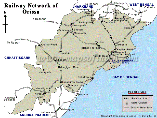
1. Railway Infrastructure: The Railway infrastructure of the KBK districts need to be drastically improved. In particular there are several approved lines that need to be speeded up. In addition there are some hanging lines that need to be extended and completed. The following shows the current Railway lines in Odisha.

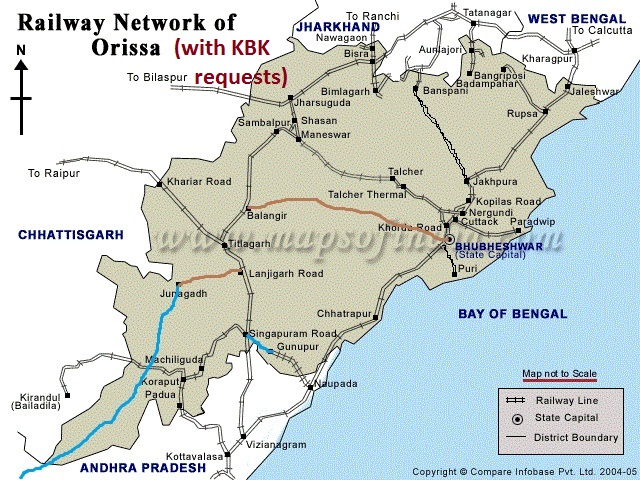
The following picture shows the lines that bring better rail connectivity to the KBK districts. The ones in brown have been approved and we request that they be completed within the next 2-3 years and. We request that the ones in blue are approved and completed within 5 years.

2. Airport at Jeypore:  Currently Odisha has one airport with commercial flights. That is in Bhubaneswar. AAI is in the process of making another airport at Jharsuguda. We propose that another airport be built near Jeypore-Koraput with commercial flights in mind (small planes to start with) to serve the KBK area. An airstrip is already there.  The following map shows the location and its distance from the other airports in India.

3. Roads: On roads, we request that the construction of the Vijaywada-Ranchi highway be expedited.  More.

4. HRD/Education: The 11th plan has good proposals regarding schools, ITIs and model colleges. But as we said in the beginning of this document, KBK needs to produce its own teachers, doctors and engineers.

As a first step the Odisha government decided to locate the Central University of Odisha in Koraput. However, considering the vast area of KBK, we request the following.

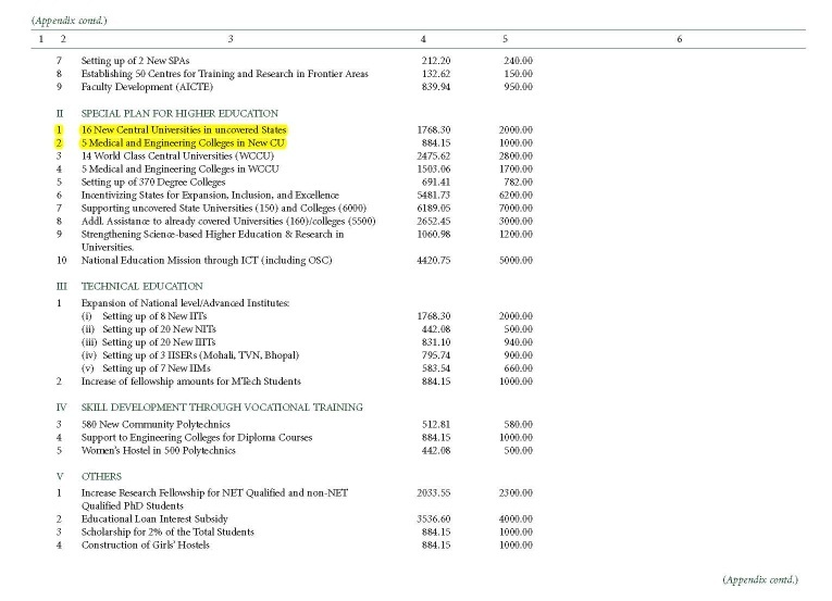
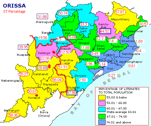
4.1   The 11th plan has provision for having medical colleges and engineering colleges in 5 of the 16 new central universities. (See the page from Volume 3 of 11th plan below.) We request that the one of those medical college and engineering college be established as part of the Central University of Orissa, Koraput.

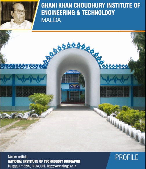
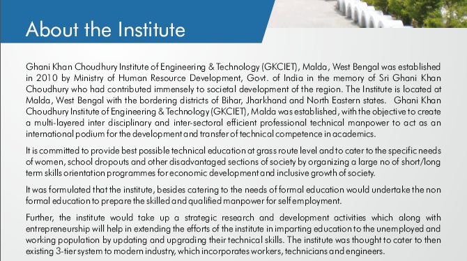
4.2   A centrally funded engineering college of the kind in Longowal Punjab (SLIET), Kokrajhar Assam and the one being made in Malda (GKCIET): These three centrally funded engineering colleges have rural focus and we request that one such rural focused 3-tier (catering to workers, technicians and engineers) is needed for KBK. We request that it be made in Balangir. In the next page we have cut-outs related to the above mentioned three colleges which show their mission perfectly matches what is needed in the KBK districts.

4.3 Upgradation of Food Craft Institute Balangir to an Institute of Hotel Management.

4.4 Some kind of a centrally funded institute in Kalahandi: One has to be realistic in pursuing something that is achievable; something central government has established in smaller towns in other states; something with similar philosophy as SLIET/GKCIET/CIT-Kokrajhar but in a different field.

Added on Dec 11th 2010: I think a Central Agricultural University can be pushed for Kalahandi. Currently a Central Agricultural University exists in Imphal (http://www.cau.org.in/). I came across the news item in http://bundelkhand.in/portal/NEWS/Centre-clears-an-AIIMS-like-institute-for-Jhansi-Bundelkhand that says "the Union agriculture ministry had given the go-ahead to develop a central agriculture university in Jhansi". So a similar one can be pushed for Kalahandi.

4.5 Special funding for proposed state Universities in KBK: The Odisha government higher education task force has recommended new state universities to be made in Jeypore (Koraput), Bhawanipatna (Kalahandi) and Balangir. We request that the central government give a one time 50 crore grant to each of these proposed universities so that they can be started at the earliest.

 5. Job Centers:


  • Wagon factory in Kalahandi.
  • Tourist infrastructure around Gandhamardan hills and Harishankar.
  • Tourist infrastructure around Kolab dam and tribal hamlets of Koraput.

6. KBK+: In addition in the KBK+ district of Kandhamal a branch of Indira Gandhi National Tribal University (IGNTU) can be realistically pursued and achieved.

Final Word: Please make additional suggestions. But be realistic. Also, note that here we are talking about what to pursue with the central government.


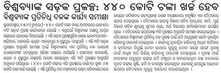
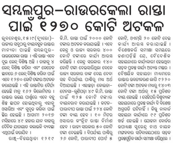
Various road development plans across Orissa: Dharitri

Cuttack, Jharsugurha, Khordha, NH 42 (261 Kms: NH-6@Sambalpur - Redhakhol - Anugul - Dhenkanal - NH-5@Nergundi), NH 5 (488 kms: NH No.6 in Jharkhand - Baripada - Baleshwar - Bhadrakh - Cuttack - Bhubaneswar - Khordha - Brahmapur - upto Andhra Pradesh Border), Sambalpur, Sundergarh, Vijaywada-Ranchi highway Comments Off on Various road development plans across Orissa: Dharitri

Roads, Bridges and other construction plans in Orissa

Brahmani river, Mahanadi River, Rivers and Bridges, Roads, highways and Bus stands, Vijaywada-Ranchi highway Comments Off on Roads, Bridges and other construction plans in Orissa

Following is culled from various news reports: Expressbuzz.com, Orissadiary and Pragativadi.

  1. Current fiscal: Broaden and repair the roads connecting from Cuttack-Banki, Barkot-Lahunipada, Balangir- Kantabanjhi, Chorada- Duburi and Udala -Baripada, Jharsuguda-Sambalpur.
  2. Bridges would be constructed near Bhubana on Brahamni river, near Jagadalpur on Anga river in Padmapur, near Jatamudia on Mahanadi river, Lalitgiri Setu on Birupa river, at Jhiripani on Koyel river and Burla Buguda Pali on Ghoda river.
  3. Road connecting to Cuttack and Paradip would be completed by June 2010. Of the 81 km, repair works in 29 km roads have been completed.
  4. The 91 km road connecting to Pandapada-Naranapada in Keonjhar district would be completed by 2011.
  5. Steps would be taken to complete the road connecting to Khurda and Balangir by 2010.
  6. The fly-over near in the busy Rajmahal Square in Bhubaneswar would be completed within two years.
  7. Vanivihar-Rajmahal Road in Bhubaneswar will be converted to an eight lane road.
  8. Tender has already been completed for construction of E-Procurement Cell at Cuttack,Construction Academy Buildings at Gopalpur, Parala Maharaja Engineering College at Brahmapur,Engineering College at Bhawanipatna, Agriculture College and Horticulture at Chipilima.
  9. The Vijayawada-Ranchi National Highway passing through 13 tribal dominated districts of the State will be completed by 2014.Chief Minister Naveen Patnaik today reviewed the progress of different road and bridge projects at a high level meeting.Out of the 1,219 km long highway, 983 kilometre falls in Orissa and will be constructed by the State Government.

Detailed route of the Ranchi – Vijaywada highway through Orissa

Vijaywada-Ranchi highway Comments Off on Detailed route of the Ranchi – Vijaywada highway through Orissa

The following is from pages 39-41 of The following is an excerpt from http://morth.nic.in/writereaddata/noticeimages/Ultimate_RFP4418252769.pdf.

Orissa part of Ranchi-Vijaywada highway – call for consultants

Vijaywada-Ranchi highway 1 Comment »

Some of the information on this is available at:

The following is an excerpt from http://morth.nic.in/writereaddata/noticeimages/Ultimate_RFP4418252769.pdf.

The Government of India with the cooperation of State Government intends to improve the communication infrastructure in the back ward area affected by naxalites and bring the backward area to the mainstream by removing the development disparity. This road has been planned to combat extremist activities in the border districts of Orissa as well as social upliftment of tribal people. The road from Vijayawada enters in Orissa at Motu in Malkangiri in south Orissa and leaves the State near Tiring in Mayurbhanj District in the north. The proposed road passes through 12 backward districts of Orissa. This road traverses through different topography. The route virtually passing middle of the State longitudinally, has been chosen carefully after identifying the disturbed area. Construction of this road shall help to bring about radical changes in the life style of the tribal people of the State, who often are subjected to coercion by extremists, by bringing in improved economic activities and improved law and order situation.

Most of the roads stretches are deficient in lane width, crust, formation height, drainage, CD works etc. It is necessary to work out an improvement strategy depending on sound engineering practice whereby all the weak points of road is attended to. Therefore, it is decided to engage Domestic Consultants to carry out the detailed project preparation for the roads & bridges by updating / redoing the available engineering data and supplementing with further investigation and data. The proposed improvement works shall consist mainly in raising the formation level, widening to two-lane from the existing single-lane/ intermediate-lane width, pavement strengthening and improving the cross drainage works. The road alignment comprises of predominantly single lane State Roads and Below Standard single lane in rural roads and DL/IL in NH stretches. The average formation width also varies considerably from 5m in Rural roads to 8 to 10m in State roads and 10-12m in NHs.. The Right of way also varies from 10m in the rural roads to 15-20m in SH/DR to 30-45m in NH. Most of the road stretches do not have appropriate geometrics. Some of the stretches have also deficient formation height.

The road is having a total length of 1219 km consisting of NH, SH, District roads and Village roads. Government of Orissa from its own resources have already started preparation of DPR of about 163 km of roads. Leaving aside the NH portion of the alignment, which will be taken up subsequently, it is decided to take up preparation of Detailed Project Report along with bid documents for balance about 600 km of SH and other category of roads. For convenience of administration, this 600 km of road has been divided to ten packages; the details of stretches which are included in the scope of work are provided in the Annexure-I.

The State of Orissa experiences annual rainfall of about 1500 mm and the maximum temperature during the summer from April to June is about 45 degree Celsius and minimum during winter from November to January is about 7 degree Celsius. The alignment is away from coastal area and the closest to the sea location is Aska and Digapahandi which will be about 50km from Bay of Bengal. The alignment is passing through predominantly plain/rolling terrain and hilly terrain.

2. OBJECTIVES The objectives of this consultancy services would be to carry out, feasibility study, detailed engineering design and project preparation (including BOQ, Bid documents and preparation of quality control manual for supervision) for the specific package indicated in Annexure-I. All the roads shall be improved to two lane carriageway with or without paved shoulder depending on the composition of traffic.

Accordingly, the objectives of this consultancy package will include: The feasibility study shall inter alias include traffic surveys, analysis and growth projections, fixing broad contour of the project, working out widening, realignment, bypass options, working out pavement rehabilitation/reconstruction options, working out rehabilitation/reconstruction options for bridges and CD works, working out schemes for various improvement features like intersections, service roads, underpasses, bus bays etc, environmental and social screening of the project and determination of preliminary cost of the project and carrying out economic analysis. Detailed Engineering Design and Project Preparation shall inter alias include detailed highway design (alignment plan and profile), design of pavement, design of bridges and CD works, design of other improvement works and road furniture, environmental and social safeguard plans, detailed working drawings, detailed cost estimate, BOQ, Economic Analysis, and Bid Document Preparation.


Update on Ranchi-Vijaywada highway

PMGSY, Vijaywada-Ranchi highway 2 Comments »

New Indian Express reports on a response given in the assembly regrading the status of the Ranch-Vijaywada highway. Following are some excerpts:

Work on the Orissa part of the Visakhapatnam-Ranchi Highway would be started after the detailed project report (DPR) is cleared by the Centre, Works Minister AU Singhdeo informed the Assembly on Friday. … the Minister said that 1,219 km of the highway would pass through Orissa. The road would connect Motu, Malkangiri, Koraput, Aska, Boudh, Keonjhar and Tiring. Singhdeo said that 237 km of the road will be national highway, 106 km would be under the Prime Minister’s Gram Sadak Yojana (PMGSY) and 215 km would be constructed with World Bank funding adding DPR is being prepared for 610 km. … the Minister said that 167 km of the road would pass through Malkangiri, 138 km through Koraput and 127 km through Rayagada districts respectively. It would pass through tribal and backward districts in which the Naxalites have spread their base. Tenders have been floated for 64.3 km long Malkangiri-Jeypore road. Besides, work has already been started for 80 km-long Phulbani-Bhanjanagar road with Rs 20 crore estimate. SMEC International Private Limited has been entrusted the survey work for by-pass to Koraput town.

Telegraph describes the route as follows:

Vijayawada- Kodar- Khammam- Motu- Malkangiri- Jeypore- Koraput- Rayagada- Digapahandi- Aska- Phulbani- Boudhi- Deogarh- Keonjhar- Tiring- Hata- Chaibasa- Chakradharpur- Khunti- Ranchi.

Progress on the Ranchi-Vijaywada highway zig-zagging through 1219 kms of Orissa

Angul, Balangir, Bouda, BRGF: Backward districts program, Central grants, Deogarh, Extremist infested districts program, Gajapati, Ganjam, Kandhamala, KBK Plus district cluster, Keonjhar, Koraput, Malkangiri, Mayurbhanj, Rayagada, Sambalpur, Sonepur, Uncategorized, Vijaywada-Ranchi highway 2 Comments »

Anubhuti Bishnoi in Indian Express reports on the progress towards making a 2-lane Ranchi-Vijaywada highway zig-zagging through 1219 kms of Orissa and passing though most of its tribal districts, many of which are naxalite infested. The article has a nice map showing which towns the road will pass through in Orissa. Following are some excerpts from that article. (Thanks to Manoj Sahu in Africa for mentioning this article in Agami Orissa.)

At a recent meeting chaired by Prime Minister Manmohan Singh, the Ministry of Shipping, Road Transport and Highways was asked to expedite finalisation of the Detailed Project Report (DPR) for the Vijayawada-Ranchi corridor cutting through Orissa, and take it up on a priority basis. … Around 1,219 km of the 1,729-km corridor planned between Vijayawada and Ranchi will fall in Orissa, and the state government had requested that its state highways, district and rural roads be incorporated in the corridor. Now 235.8 km of national highway sections, 878 km of state high ways and 104.5 km of rural roads will be a part of the corridor. The road from Vijayawada enters Orissa at Motu in Malkangiri district and leaves at Tiring in Mayurbhanj district on the north. … While the Ministry may not call the stretch NH as yet, with the Prime Minister taking a keen interest, it is set to be developed as per national highway standards. What that means is that tribal areas of Koraput, Malkangiri, Rayagada, Gajapati, Ganjam, Kandhamal, Anugul, Sambalpur, Deograh, Keonjhar, Mayurbhanj and Boudh, currently insurgency hotbeds, may emerge out of the hinterlands. Confirming that the project had been put on the fast track, a senior Ministry of Shipping, Road Transport and Highways official said: “The DPR of the corridor is underway and should be ready in six-seven months.”

Note: As mentioned by Digambara a map of the route is at http://tathya.in/story.asp?sno=592. I removed the faulty map that Indian Express printed.

Roads and Highways infrastructure in Orissa

Angul, Balangir, Balasore, Bargarh, Baripada-Balasore-Kirtania, Bhadrakh, Bhadrakh-Balasore, Bhadrakh-Dhamara, Bhubaneswar-Berhampur, Bhubaneswar-Cuttack- Kalinganagar, Bhubaneswar-Dhenkanal- Anugul, Bhubaneswar-Nayagarh, Bhubaneswar-Paradip, Bhubaneswar-Pipli- Astaranga, Bhubaneswar-Pipli- Konark, Bhubaneswar-Puri, Bouda, Choudwar-Kendrapara - Dhamara, Coastal highway, Corridors emanating from Bhubaneswar metro, Cuttack, Cuttack-Paradip, Deogarh, Dhenkanal, DISTRICTS & BLOCKS, Gajapati, Ganjam, Grama sadak, Jagatsinghpur, Jajpur, Jharsuguda-Sambalpur- Bargarh, Jharsugurha, Kalahandi, Kalinganagar - Kamkhya Nagar - Talcher, Kalinganagar - Panikoili - Jajpur - Kendrapara, Kalinganagar - Tarini - Keonjhar, Kalinganagar- Chandikhol- Paradip, Kalinganagar-Bhadrakh, Kandhamala, Kendrapada, Keonjhar, Khordha, Koraput, Malkangiri, Mayurbhanj, Mining Corridor, Nabarangpur, National Highways, Nayagarha, NH 200 (440 Kms: Chhattisgarh - Jharsuguda - Deogarh - Talcher - Kamakhyanagar - Duburi - Chandhikhol), NH 201 (310 Kms: Boriguma - Bhawanipatna - Balangir - Bargarh), NH 203 (97 Kms: Bhubaneshwar-Pipili-Puri-Konark), NH 203A (49 Kms: Puri - Bramhagiri - Satpada), NH 215 (348 Kms: NH-5@Panikoli - Anandapur - Kendujhargarh -Rajamundra @NH-23), NH 217 (438 Kms: Chhattisgarh Border - Khariar Rd - Nuapada - Khariar - Titlagarh - Ramapur - Baligurha - Asika - Brahmapur - Gopalpur), NH 224 (298 Kms: Khordha - Nayagarh - Dashapalla - Bauda - Sonapur - Balangir), NH 23 (209 Kms: Jharkhand Border - Rourkela - Rajamundra - Pala Laharha - Talcher - NH-42), NH 42 (261 Kms: NH-6@Sambalpur - Redhakhol - Anugul - Dhenkanal - NH-5@Nergundi), NH 43 (152 Kms: Chhattisgarh Border - Chandili - Borigma - Jaypur - Koraput - Sunki - Andhra Pradesh Border), NH 5 (488 kms: NH No.6 in Jharkhand - Baripada - Baleshwar - Bhadrakh - Cuttack - Bhubaneswar - Khordha - Brahmapur - upto Andhra Pradesh Border), NH 5A (77 Kms: NH-5 at Chandikhol to Paradip), NH 6 (462 Kms: Chhattisgarh Border - Lobarchatti - Bargarh - Sambalpur - Deogarh - Kendujhargarh - Jashipur - Bangriposi - Jharkhand Border ), NH 60 (57 Kms: West Bengal Border- Jaleswar - Baleshwar), NH 75 (18 Kms: Jharkhand Border to NH-215 near Parsora), Nuapada, Overall Odisha, Puri, Puri - Konark, Rayagada, Road maps, Roads, highways and Bus stands, Rourkela-Jharsuguda, Sambalpur, Sonepur, State highways, Sundergarh, Vijaywada-Ranchi highway Comments Off on Roads and Highways infrastructure in Orissa


In recent years there has been a big jump in the number of kilometers of national highways in Orissa. Following is copied from my page "Roads and Highways infrastructure in Orissa."

Road network: Orissa Roads1; Orissa Roads2; India’s NH network; India’s golden quadrilateral; the part of the GQ/NH-5 that runs through Orissa.

  • National Highways in Orissa and India; its growth in recent years:
    • NH 5: Junction with NH No.6 in Jharkhand near Baharagora-BaripadaBaleshwar-Bhadrakh-Cuttack- Bhubaneswar-Khordha-Chhatrapur-Brahmapur– upto Andhra Pradesh Border. (488 kms)
    • NH 5A: Junction with NH No.5 near Haridaspur-Paradip Port. (77 kms)
    • NH 6: From Chhattisgarh Border-Lobarchatti- BargarhSambalpur-Deogarh-Barakot- Kendujhargarh -Jashipur-Bangriposi-upto Jharkhand Border (462 kms)
    • NH 23: From Jharkhand Border-Panposh-Raurkela– Rajamundra-Barakot- Pala Laharha-Talcher-Jn. with NH-42 (209 kms)
    • NH 42: Junction with NH No.6 near Sambalpur– Redhakhol-Anugul-Dhenkanal- Jn. with NH-5 near Cuttack. (261 kms)
    • NH 43: From Chhattisgarh Border– Dhanpunji- Borigma- JaypurKoraput-Sunki- Andhra Pradesh Border. (152 kms)
    • NH 60: From West Bengal BorderJaleswarBaleshwar (57 kms)
    • NH 75: From Jharkhand Border to junction with NH No.215 near Parsora (18 kms)
    • NH 200: From Chhattisgarh-Machida-Jharsuguda– Kochinda- Deogarh –Talcher-Kamakhyanagar-Sukinda- Chandhikhol (440 kms)
    • NH 201: Boriguma-Ampani-Bhawanipatna– Belgan- Balangir-Luisinga-Jogisuruda-Dunguripali-Bargarh (310 kms)
    • NH 203: Bhubaneshwar-Pipili-PuriKonark (97 kms)
    • NH 203A: The highway starting from its junction with NH-203 at Puri, connecting Bramhagiri and terminating at Satpada (49 kms)
    • NH 215: Panikoli-Anandapur-Ghatgan- Kendujhargarh– Parsora-Koira-Rajamundra (348 kms)
    • NH 217: From Chhattisgarh Border-Nauparha-Khariar- Titlagarh-Belgan- Ramapur- Baligurha-Sorada-Asika- Brahmapur– Narendrapur- Gopalpur (438 kms)
    • NH 224: Khordha-Nayagarh-Dashapalla- Purunakatak-Bauda-Sonapur-Balangir (298 kms)
  • Vijaywada-Ranchi highway (approved by planning commission as reported in May 2006), [July 06] [The Orissa government has been demanding a NH from Vijaywada to Ranchi which will pass through the Naxal infested areas. 1200 km of this 2000km will be in Orissa. CM talked to planning comission about it.]
  • Ongoing National Highway work in Orissa
  • Future plans for Orissa: [1:april-28-05]; [2:april-28-05].
  • Various phases of NHDP: [1]; [2]; [3]
  • Other highway plans:
    • 4 laning of Chandikhol-Paradip by February-end of 2007
    • 4 laning of Keonjhar-Panikoili, Duburi-Talcher, Cuttack-Paradeep and Duburi-Keonjhar Highways. [June17-05-Pragativadi]
  • Aim-for-with-high-priority/parts-of-it-in-Orissa-govt- plan(page4)-already:
    • Connect NH 215 (perhaps at Jajpur Rd) to Jenapur to NH200 (where it meets Brahmani) with a highway as Jenapur is the location where the National waterway will cross the railway line and Jenapur is 7 kms from where a branch of the line goes to Daitari and Bansapani.
    • Designate AP-border-Koraput-Raygada-Padampur- Berhampur (in NH5) as a National highway. (This will bring Koraput and Raygada, thus a big part of KBK, closer to BBSR) — a slight revision of what is in the plan
    • Designate Anandpur (NH 215)-Bhadrak-Dhamara port as an NH. (This will bring Dhamara port closer to Jharkhand, thus helping industries in Jharkhand and Orissa.)
    • Jagatpur-Kendrapara-Chandbali-Dhamara — make it an NH (alternative route to Dhamara port)
    • Panikoili/Kuakhia-Jajpur-Aradi-Chandabali — make it an NH (alternative route to Dhamara port)
    • Panikoili-Jajpur-Kendrapara-NH5a-Paradeep — make it an NH (alternative to Paradeep port)
  • Orissa State Road Transport Company (OSRTC)
  • Wide city roads:
    • Four-laning of the Airport-Dhamana Chhaka road in Bhubaneswar: [1]
    • Other Bhubaneswar Road plans: [1], [2]
  • Bhubaneswar area road plans: